Skip links

ADLaS

Atmospheric Dispersion Lagrange Simulation

High resolution prediction software which calculates and simulates dispersion of air pollutants and CBRN incidents based on Lagrangian Dispersion Model.

MetAM

Meteorological Area Model

PS

Particle Simulation

DM

Dispersion Model

AM

Agent Management

Serving Industries

ADLaS calculates the dispersion of pollutant particles based on Lagrange dispersion model to help public safety responders and emergency management personnel for emergency planning of 3D CBRN releases and predicts their time-dependent changes.

Emergency Management

Depending on evaluated data Safekit can provide protection guide against incident and treatment principles to victims. This emergency chain management is completed to find best possible way to reach the specified targets in contaminated zone and escape from this zone to accomplish a mission.

Defence & Security

Depending on evaluated data Safekit can provide protection guide against incident and treatment principles to victims. This emergency chain management is completed to find best possible way to reach the specified targets in contaminated zone and escape from this zone to accomplish a mission.

Research and Development

Depending on evaluated data Safekit can provide protection guide against incident and treatment principles to victims. This emergency chain management is completed to find best possible way to reach the specified targets in contaminated zone and escape from this zone to accomplish a mission.

Information Technologies

Depending on evaluated data Safekit can provide protection guide against incident and treatment principles to victims. This emergency chain management is completed to find best possible way to reach the specified targets in contaminated zone and escape from this zone to accomplish a mission.

Enhanced & Scientific Modelling of the Contamination

ADLaS is functional for security and defence professionals, city planners, environmental researchers, municipalities, environmental protection bodies, and institutional & industrial research departments for modelling contamination in Enhanced & Scientific manner.

MetAM

Meteorologic Area Model

METAM is an application designed to enhance the spatial resolution of wind data from meteorological datasets in NetCDF format. It uses topographical features, such as elevation, and other parameters like temperature and pressure.

The application interpolates data horizontally across vertical surfaces to predict wind components for a specified region and resolution. To account for terrain elevation's impact on wind velocities, METAM simulates a three-dimensional wind field using a mass-consistent modeling approach and solves equations with the finite difference method.

The Bi-CGSTAB algorithm is employed for efficient computation of wind speed components at discrete points. This combination of techniques allows METAM to refine wind data resolution and analyze the relationship between topography and wind patterns, making it a valuable tool for meteorological research and environmental analysis.

PS

Particle Simulation

A particle simulation uses wind speed data from meteorological sources or enhanced resolution data from METAM to model particle distribution over time on the Earth's surface.

Employing a Lagrangian particle dispersion model, it simulates particles from events like explosions or chemical releases, displaying their coordinates, altitude, and density on geographic maps in 2D or 3D at specific time intervals.

This allows for observation of particle settling over time on digital terrain models. The simulation outputs help analyze particle distribution, assess environmental impact of pollution, and evaluate mitigation measures by calculating pollutant concentrations, deposition rates, and other metrics at specific times and locations.

DM

Dispersion Model

The Lagrangian particle dispersion model calculates particle deposition and movement over time, treating each particle as a Lagrangian tracer. It uses equations of motion and the Monte Carlo method to account for turbulent dispersion effects on wind speed.

The model also considers particle settling to the Earth's surface through dry deposition, influenced by surface topography, and includes scenarios where particles either bounce off or adhere to the surface.

Outputs such as particle concentrations and deposition rates are provided for specific locations and times, aiding in air quality assessment, pollutant dispersion studies, and environmental management decisions.

AM

Agent Management

In particle dispersion model, agent management typically refers to the control and manipulation of agents within the simulation. Agents in Adlas application represent individual air particles.

Before the model is developed, agents are initialized at specific locations and times within the model domain. The diameters and densities of particles can directly influence the results of the generated particle dispersion model and simulation, creating different distribution scenarios. Adlas currently supports 12 different particle types but it is also capable of supporting the modeling and simulation of different particle types.

Enhanced Modelling Level Abilities

Actual and Future Meteorology Data
Creating Chemical Model of Agent Properties
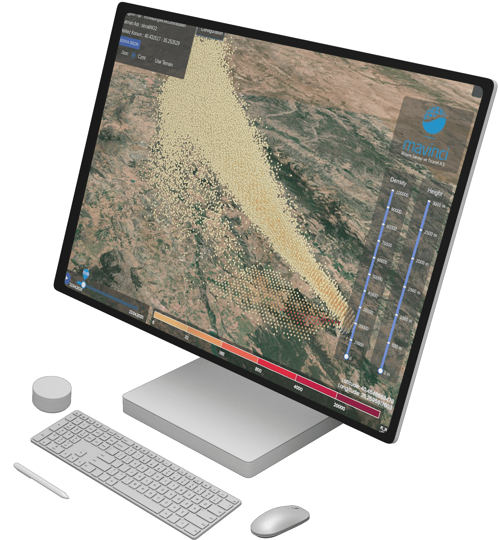
2D & 3D Modelling and Simulation
Determination of the Contamination Area
Deposition and Dose of Trace Species
Impact Analysis of CBRN Incident
Creating Physical Model of Agent Properties
Particle Movement and Interaction Modelling
Source Receptor Analysis
Concentration of Agent on Contaminated Area
Precipitation Rate and Intensity
Grid Resolution: 20m to a few hundred km’s

Request a Demo

Please enable JavaScript in your browser to complete this form.

** We respect your privacy and do not tolerate spam and will never sell, rent, lease or give away your information to any third party.

Explore
Drag